
Axis protege el parque natural del Campo dei Fiori para prevenir incendios
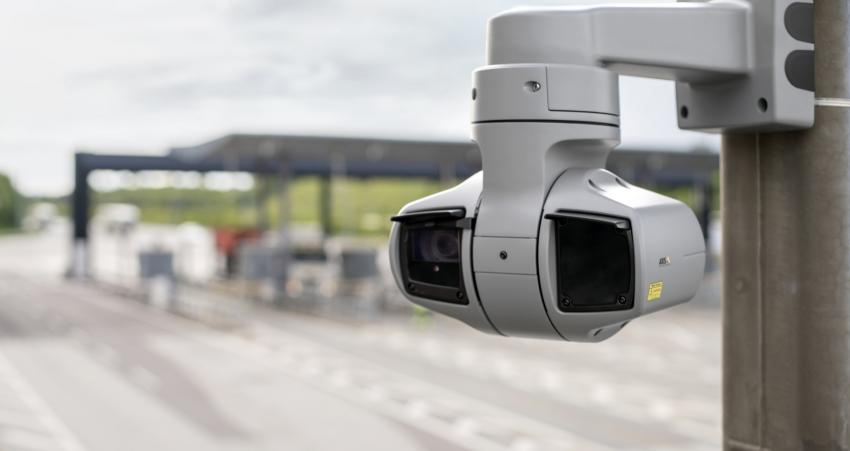
Tres cámaras de la serie Axis Q6225-LE permiten cubrir buena parte de este parque, situado cerca de la ciudad de Varese, gracias a su alta capacidad de zoom y a la integración con el Security Center VMS de Genetec.
La autoridad del Parque Natural Regional de Campo dei Fiori precisaba de un sistema de seguridad sólido, que permitiera proteger el medio ambiente y sus habitantes, ya que el obsoleto sistema de vigilancia analógico no respondía a las necesidades que se precisaban. Es por esto que la infraestructura analógica existente ha sido reemplazada por una solución basada en la tecnología digital de Axis.
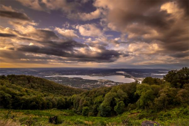
El Parque Natural Regional de Campo dei Fiori es un organismo de derecho público situado a pocos kilómetros al norte de la ciudad de Varese (Italia).
Establecido por la Ley Regional no. 17 of 19 de marzo de 1984 y ampliado en 2009, se extiende sobre aproximadamente 6.300 hectáreas de terreno en 17 municipios y dos comunidades de montaña en la provincia de Varese. Su situación geográfica y características geológicas han favorecido el desarrollo de una vegetación muy diversa, con zonas ricas en fauna. Presencias histórico-arquitectónicas importantes incluyen el complejo del monte sagrado de Varese (calificado como patrimonio de la Unesco), el Gran Hotel, las villas Art Nouveau, la abadía de Ganna y la Rocca di Orino.
In October 2017, un violento incendio azotó el parque, dejando tras de sí una gran devastación. For almost a month, several fire outbreaks involved firefighters and civil protection agents in a fierce effort to defend the forests, the animals, the houses and businesses. More than 350 hectares of forest were destroyed and the estimated damages exceeded 2.000.000 euros. Subsequently, in 2019 a new man-made fire devastated about 318 hectares of forested area.
Facing the threat of increasingly extreme fires due to climate change, the Park authority saw the need to install a strong surveillance system that would allow the park and its inhabitants to be protected.
For the Park authority, it is clear that moving forward with interventions in forests and infrastructures is of crucial importance. It is necessary to respect the environment and take care of the territory with projects and continuity, with a long-term perspective.
It is with this perspective that Maurizio Fratini, CTO of Security Service Red, Axis partner and consultant to the Park authority, proposed replacing the obsolete analog surveillance system with an integrated solution composed of Axis network cameras with built-in deep learning modules and Genetec video management software.
“The need of the Park authority was to have network cameras characterized by powerful zoom and advanced video analysis capabilities, considering the large area to be monitored. Furthermore, a brain was also required, the cameras that have been installed are designed as IoT sensors, especially taking into account future scalability”, comments Maurizio Fratini.
The project was carried out in two phases. En un primer momento se apostó por la monitorización e investigación proactiva y luego se optó por dirigirse hacia el análisis predictivo.
La Autoridad del Parque ha encontrado una solución que satisface sus necesidades y aprecia la efectividad y simplicidad de operación, que ofrece toda la flexibilidad necesaria para calificar como una mejor práctica para quienes se ocupan de incendios forestales.
Con solo 3 cámaras de la serie Axis Q6225-LE, se ha podido cubrir buena parte del área del parque, gracias a la alta capacidad de zoom y la integración con el Security Center VMS de Genetec. La sala de control remoto tiene dos monitores, uno que muestra el mapa del parque y el otro que transmite imágenes de la cámara.
This integrated setup uses metadata to allow operators to respond to potential risk situations, identifying their exact location for a more detailed examination. The high quality of the images also facilitates the use of video images for research purposes, to later analyze, after the event, where and how the fire developed.
Among the priorities focused on in a second phase is prevention to limit and seek to contain and eliminate events such as forest fires that would compromise the mountainous ecosystem, impacting a heritage of great naturalistic importance.
Likewise, human intervention has been reinforced with innovative technologies, carrying out territorial surveillance with optical systems that allow the observation of a wide area even remotely.
The deep learning modules integrated into the cameras pave the way for the system to detect and provide crucial information for predictive analysis. The cameras learn the stable conditions of the forest and, with dedicated analyses, they simulate potential risk situations based on changes.
In this sense, currently evaluations of three different scenarios are being carried out, with the aim of selecting the optimal solutions for each context and validating them at a technical-scientific level. The agency's intention for the Park is to become a point of reference, a good practice to follow for other institutions interested in the prevention and protection of the territory.
An additional added value has been given with the activation of tablets for the mobile units and for the Firefighting Operations directors, in order to have real-time information on the situation and development of possible fires but also as a prevention analysis tool.
“Since the most dangerous fire is the one that is not seen, which develops underground and which is technically called 'root to root', in the future there is a possibility of adding thermal cameras to the system, which would allow receiving an alarm. if the soil temperature were abnormal”, states
Maurizio Fratini.
¿Te gustó este artículo?
Subscribe to our NEWSLETTER and you won't miss anything.