
Esri and Nexus Geographics digitize capacity control on beaches with Safe Spaces
Available for any municipality, Esri y Nexus Geographics have combined technologies in Safe Spaces, a comprehensive solution based on cloud technology and smart location.
Esri, specialist in geographic information systems (GIS), y Nexus, in geolocation and smart maps, have presented Safe Spaces, a comprehensive solution for municipalities based on cloud technology y smart location (location intelligence), which includes applications for tourists and residents, a personalized public consultation website and dashboards for managers, lifeguards and workers.
Safe Spaces offers información en tiempo real on occupancy, safety measures and the status of beach flags, available for any municipality needing to manage spaces where it is necessary to control capacity, que ya ha sido probada con éxito en varios municipios baleares, como Palma de Mallorca.
Optimizar la gestión del aforo en aquellos lugares donde se puede producir acumulación de gente, como es el caso de las playas en un contexto de pandemia, se ha convertido en una necesidad para reforzar un sector esencial para la economía española.
La industria turística ha tenido que hacer frente a una reducción del 77% en su volumen de negocio entre 2019 y 2020 y, según datos de la Confederación Española de Organizaciones Empresariales (CEOE), aportará un crecimiento de entre uno y dos puntos del PIB en 2021, between 66.435 y 77.273 million euros, cifra que supone un 50% de la aportación en 2019.
La complejidad de la gestión de las playas, un espacio público sujeto a normativa en constante evolución, con la necesidad de informar a visitantes, residentes y trabajadores precisa de canales de información digitales que faciliten el acceso y su disfrute de manera segura.
La solución integral Safe Spaces se ha desarrollado a partir de ArcGIS Online y basada en tecnología cloud para facilitar un despliegue rápido y eficiente.
Dirigida tanto a ayuntamientos, socorristas, gestores y turistas y residentes, Safe Spaces ofrece a cada uno de estos colectivos un canal de comunicación específicamente diseñado para sus necesidades. Concretely, Safe Spaces comprende cuatro aplicaciones diferentes:
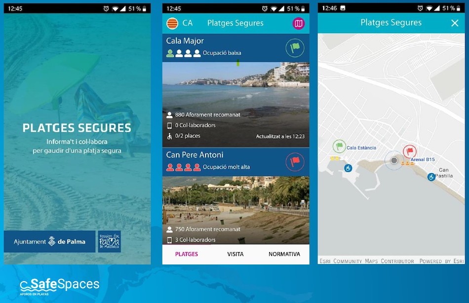
App para turistas y residentes: que permite consultar el estado de ocupación de las playas, de las banderas, de las zonas de accesibilidad, así como las medidas de seguridad adoptadas en cada playa.
La app puede adaptarse también a la imagen institucional del ayuntamiento y es compatible con múltiples idiomas (castellano, catalán, inglés y alemán) y dispositivos iOS y Android. Besides, permite registrar voluntariamente la estancia en la playa y opinar sobre los servicios mediante encuestas.
App para socorristas e informadores: además de la información ofrecida en la anterior app, incluye otra de utilidad práctica para la gestión de la playa, para informar de los cambios de aforo, del estado de la bandera o de la situación en plataformas de accesibilidad, y es compatible con sistemas iOS y Android.
Cuadros de mando de gestión municipal: dirigidos a técnicos municipales, así como a cuerpos de seguridad y de emergencias, these dashboards provide key real-time information, as well as historical data on beach occupancy for better and faster decision-making.
Public information website: easily integrated into the municipality's web portal, operates as an additional channel to inform users in real time about the aforementioned aspects, on panels and screens, which can also be customized with the city council's image.
The objectives of Safe Spaces are to improve tourist safety, with real-time information of interest to enjoy the beaches safely; avoid unwanted crowds and control capacities.
Its deployment is carried out in just four weeks and there is no need to invest in additional hardware, como cámaras, sensores o nuevos servidores. La solución es escalable para incorporar nuevos desarrollos, como mapas turísticos, sistemas de avisos o compatibilidad con sensores de conteo.
¿Te gustó este artículo?
Subscribe to our NEWSLETTER and you won't miss anything.