


Esri empowers real-time intelligent information with emergency services with Safe Communities
New smart maps from Esri's ArcGIS platform connect emergency services in real time to prevent and respond to disasters and conflicts.
 The specialist in geographic information systems (GIS) Esri has enhanced its ArcGIS platform with the Safe Communities solution, aimed at improving communication and information in real time of the different emergency agents in the event of natural disasters, mass events, border control, etc.
The Safe Communities solution facilitates and speeds up the decision-making process in these types of critical situations, where the time spent can lead to economic losses and even human lives, since it allows emergency centers and field personnel to coordinate in an agile manner, sharing and analyzing data in real time for better decision making.
ArcGIS for Safe Communities can be used in any of the four phases of emergency management: prevention, answer, mitigation and recovery. For example, By analyzing historical data it is possible to develop predictive models to evaluate the possible impact of a future event, assisting in prevention tasks.
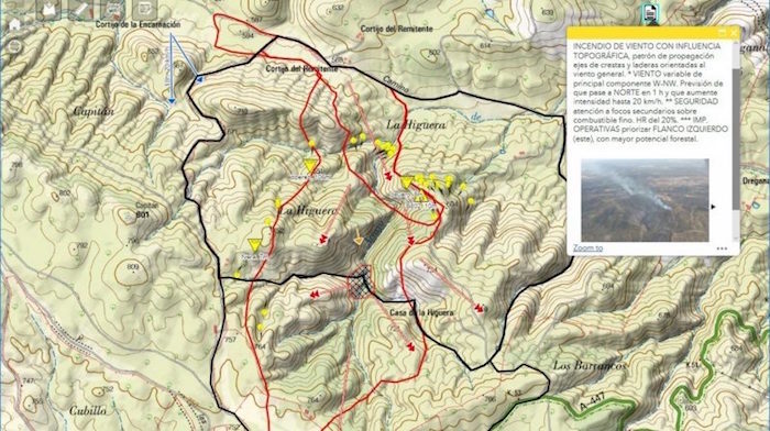
 In addition, It is possible to mitigate natural disasters at the same time they occur, collecting information in real time that allows various magnitudes to be analyzed in real time, like the location of a fire, wind speed or location of deployed response teams.
Proof of its efficiency is the use of ArcGIS to combat pests and harmful species, as in the case of the Madrid City Council; or to detect areas with high probability of fire in the case of the Barcelona council and in the community of Andalusia, where Infoca used it to manage the extinction of the fire that devastated part of the Doñana National Park last year.
Another possibility is that private companies can develop new solutions using ArcGIS as a technological base., for applications as diverse as the analysis of the behavior of forest fires and the simulation of their propagation, as is the case of the Wildfire Analyst system Tecnosylva.
As Álvaro Martín points out, industry manager executive of Public Administration at Esri Spain, “technology has to be flexible and scalable to react to an emergency, providing real-time data exchange and guaranteeing fast and accurate decision-making in any phase of an emergency, and by any of the multiple organizations that participate in its management”.
¿Te gustó este artículo?
Subscribe to our NEWSLETTER and you won't miss anything.