


The Ignis project provides a solution that optimizes safety in forest fires
Through a combination of satellite communications and the use of a UAV, the Ignis project, led by Hispasat, offers a solution that helps improve the safety of personnel involved in a forest fire.
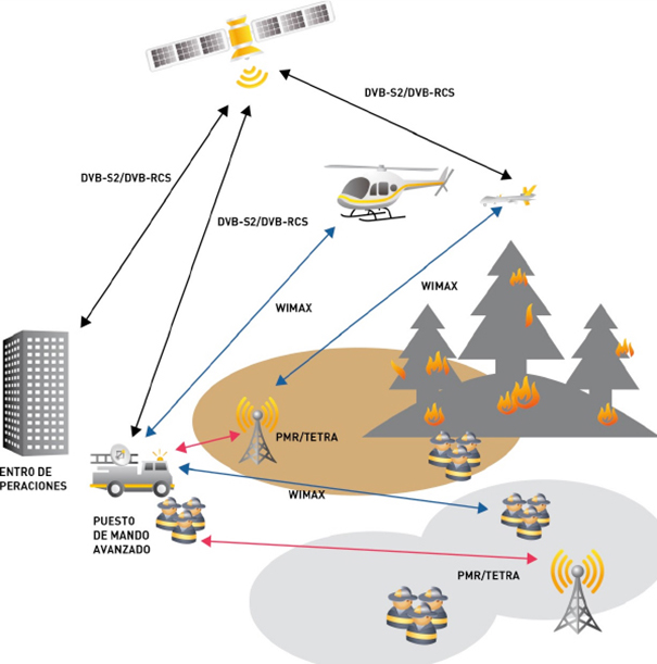
The developments carried out in the Ignis project allow firefighting operations to be conducted more efficiently and safely, as all personnel involved will have more reliable real-time data on the situation.
To achieve these results, Ignis conducted a demonstration in which it used communications from Hispasat to send, through a network infrastructure that combines satellite transmission and Wimax, the location and video obtained from an unmanned aerial vehicle (UAV). This information is received in real time at the command posts, making it possible to more accurately know the progress and evolution of the flames and to prevent emergency personnel from taking unnecessary risks.
The Ignis project arose from the conclusions obtained in an R&D project, which also involved the participation of Hispasat (the Prometeo project), and which was responsible for analyzing the parameters and processes of satellite remote sensing data, así como nuevas tecnologías y arquitecturas de telecomunicaciones que permitieran la extinción nocturna de incendios. Ignis ha continuado el estudio iniciado en Prometeo mediante el desarrollo, en un corto espacio de tiempo, de un sistema que mejora las infraestructuras actuales de telecomunicaciones utilizadas en la lucha contra el fuego.
Junto con Hispasat, Ignis ha contado con la participación de diversas empresas y entidades del sector, como Inaer, Albentia, ISDEFE, el Centro Avanzado de Tecnologías Aeroespaciales (FADA-Catec), la Universidad Politécnica de Madrid y Tecnalia.
¿Te gustó este artículo?
Subscribe to our NEWSLETTER and you won't miss anything.